A wind advisory with gusts as high as 60 miles per hour at times was in effect for the entire Chicago area Wednesday, including Kenosha County in Wisconsin and parts of northwest Indiana, with wind-whipped snow showers and reduced visibility all possible amid one of the busiest travel days for the Thanksgiving holiday.
The powerful winds come after a cold front swept across the Chicago area overnight, which also brought much colder temperatures in the 30s and even lower wind chills. In other parts of the Midwest, including Wisconsin, Michigan and Minnesota, winter storm warnings were in effect. The storms led to a ground stop at O’Hare airport Wednesday morning for Milwaukee and Minneapolis due to ice.
“It will feel like the 20s all day,” NBC 5 Storm Team Meteorologist Kevin Jeanes said Wednesday morning. “At times, it will feel like the teens.”
According to the National Weather Service, the advisory will remain in effect until 9 p.m., with westerly winds of 25 to 35 mph and frequent gusts up to 50 mph. Sporadic, localized gusts could be even higher, the NWS said, reaching 55 to 60 mph.
The highest wind gusts were expected during the daytime hours, between 3 p.m. and 8 p.m., Jeanes said, though wind gusts as strong as 53 mph were already reported in some parts.
“Gusty winds will blow around unsecured objects, including holiday decorations,” the advisory said. “Tree limbs could be blown down and a few power outages may result.”
Such strong winds could also make driving difficult, the NWS warned, with flurries and poor visibility at times. Any heavier “bursts” of snow that develop would mainly be near and north of I-80.
Overnight, and into Thanksgiving morning, wind chills will drop into the teens, Jeanes said, making for very cold conditions for Turkey Trot runners.
Thanksgiving will also see some sunshine, Jeanes said, with a high of 32 degrees.
Temperatures will remain cold Friday but winds will subside slightly. By Friday night, snow was expected to begin, Jeanes said, with light snow into Saturday morning but picking up by afternoon.
The snow could cause problems for post-holiday travel.
“Any snow that’s on the ground, its going to stick around for awhile as temperatures stay below freezing next week,” Jeanes said.
By Sunday, snow accumulations were expected to be anywhere between two and six inches, with even higher amounts possible in the west and northwest counties. Along the lake front, in Chicago and in counties to the south and southwest, between three and six inches of snow was possible, Jeanes said.
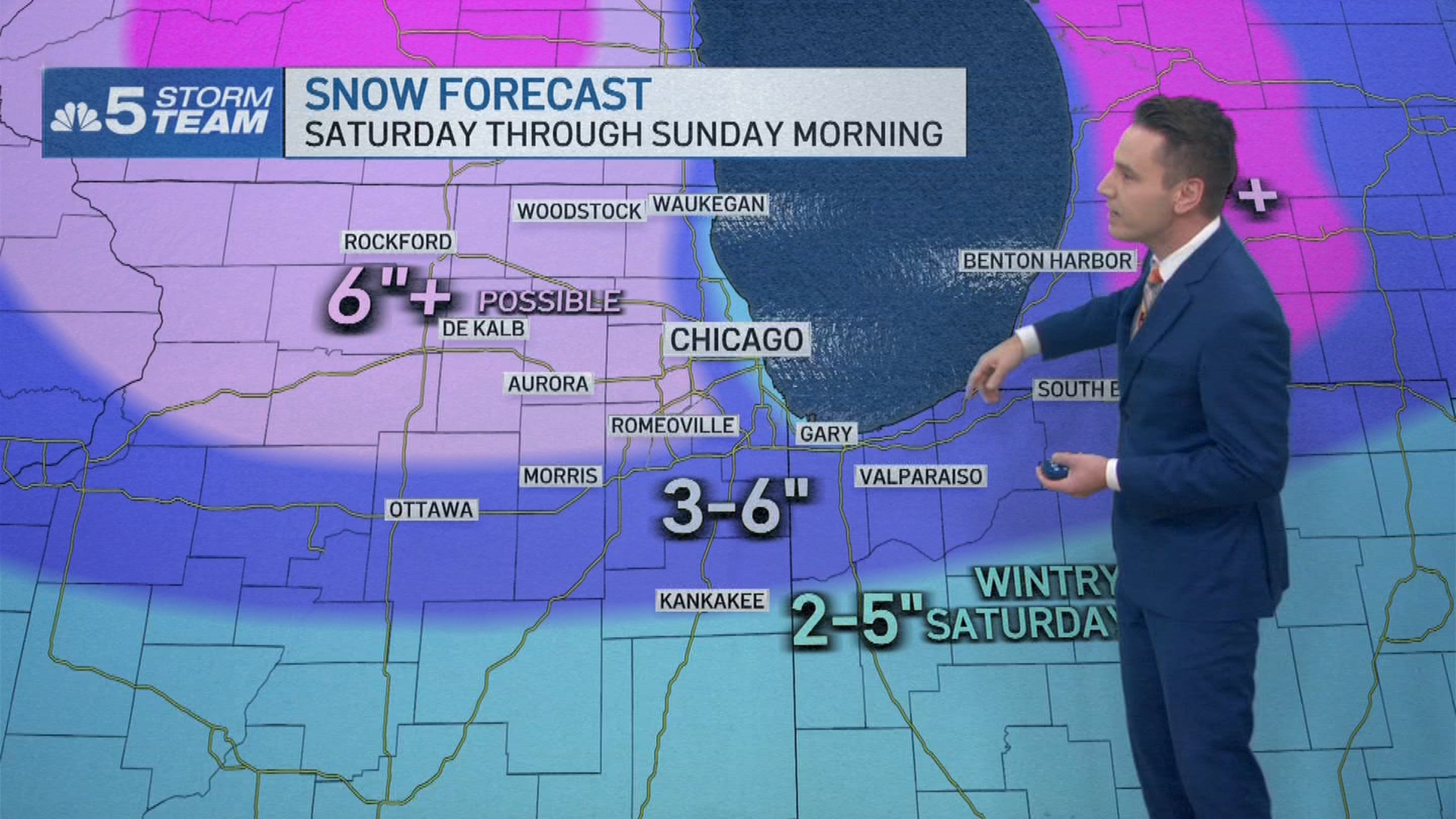
In Kankakee County and in northwest Indiana, a wintry mix with lower snow totals was expected.
After the holiday weekend, temperatures will drop even lower, with highs in the 20s for the first week of December, Jeanes added.
The cold and snow comes as new weather predictions show potential for an “active” start to December weather and through meteorological winter for 2025-26.
This story uses functionality that may not work in our app. Click here to open the story in your web browser.
Want more insights? Join Grow With Caliber - our career elevating newsletter and get our take on the future of work delivered weekly.
