In a new outlook from the National Weather Service, the Chicago area appears to be in for a potentially “active” start to December.
The latest predictions, released Thursday, indicate the region is in for a shift compared to last December.
“The end of November-start of December is favored to get off to a colder, possibly active start,” the NWS Chicago reported. “For December overall, in a change from most recent Decembers, signs pointing toward a colder start to meteorological winter 2025-26, possibly more active as well.”
The outlook for Nov. 28 through Dec. 4 showed colder temperatures and above-average precipitation expected.
This comes as the NBC 5 Storm Team monitors the potential for a blast of arctic air around and after Thanksgiving Day.
NBC 5 Storm Team Meteorologist Kevin Jeanes reported earlier this week that ridging in the jet stream in the Pacific Northwest and potentially something called a “Sudden Stratospheric Warming” (SSW) event could bring a burst of cold to the area.
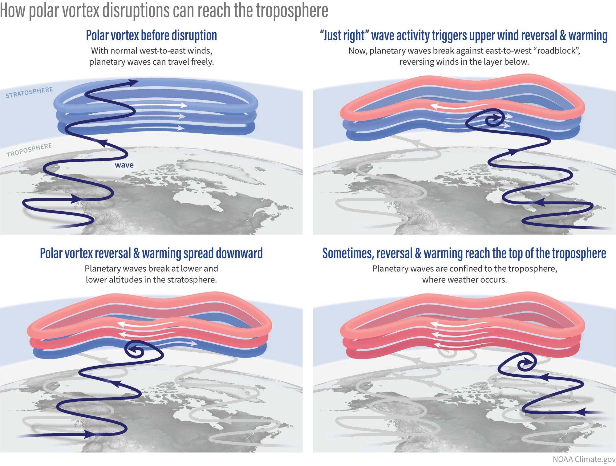
An SSW is when large-scale waves in the atmosphere, called Rossby waves, get pushed higher into the atmosphere. This causes air to sink and warm rapidly around the polar vortex, which can dislodge and send the cold air southward into the mid latitudes, rather than staying bottled up near the North Pole.
The National Weather Service’s Climate Prediction Center reported Tuesday that “the combined effects from the current La Nina, the Madden-Julian Oscillation, and potential for a rare November Sudden Stratospheric Warming event may usher in a significant pattern change later in the month and into early December.”
The agency predicts a colder pattern is “likely” for the West and Northern and Central Plains, with much of the central and northern U.S. transitioning to a colder pattern by early December.
“This pattern change favors a transition to more winter-like conditions across the west-central and central U.S. including much below normal temperatures and the potential for heavy snow,” the forecast stated.
Still, there remains uncertainty surrounding the predictions.
This is unusually early in a season for an SSW event to occur, so the polar vortex isn’t fully “set up” yet, making it more difficult for forecast models to pinpoint where the cold air will end up.
Even if it reaches the Chicago area, the arctic isn’t as cold as it would be if such an event were to happen in January or February. So an early December cold blast may mean temperatures in the 20s, not below zero like those typically seen deeper into the winter season.
What about snow?
Early signs are showing some moderate snow staying south of the Chicago area through the end of November, but there are signs the region could see one or two snow-producing storms in the first week or two of December.
The jet stream will dictate the track of the snow as it gets closer.
The NBC 5 Storm Team will continue tracking the latest weather conditions. Check here for updates.
This story uses functionality that may not work in our app. Click here to open the story in your web browser.
Want more insights? Join Grow With Caliber - our career elevating newsletter and get our take on the future of work delivered weekly.
